| |
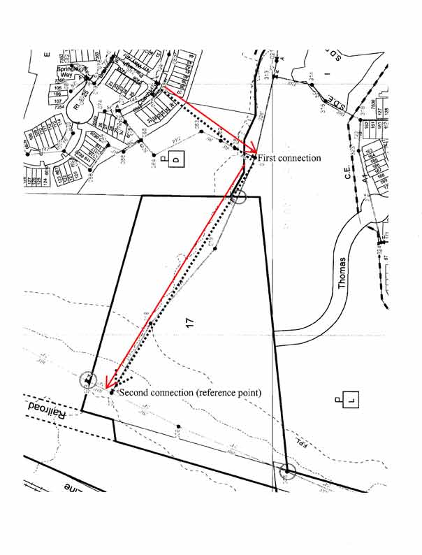
| The easiest way to see the property is to walk down the clearing between the two townhouses at 6541 and 6543 Coachleigh Way (start of red arrows) and follow the sewer line inspection plates in the sewer line easements (to the end of the red arrows). There are three sewer lines and two connections. |
| Part way down the first clearing you will see the inspections plates for the first sewer line. Continue down the clearing following these inspections plates until this sewer line connects perpendicularly with a second sewer line at the bottom of the hill. This first connection can be identified by two inspections plates fairly close together (20 feet?). Turn right and follow the inspection plates of this second sewer line down another clearing until it connects perpendicularly with a third sewer line. This third and large (24 inch) sewer line has raised inspection plates. This second connection can be identified by it's two raised inspection plates fairly close together (50 feet?). The boundaries of the property can be estimated by standing at this second connection and using it as a reference. |
| The northern boundary of the property is near the first raised sewer plate (not counting the plate at the reference connection) to the north (101 feet). The southern boundary is near the second raised sewer plate to the south (766 feet). The eastern bounday is roughly between the second and third sewer plates to the east on the second sewer line (about 911 feet). The approximate western boundary is the old railroad bed. |
|
|